China deployed a radar satellite on Wednesday morning for disaster prevention, emergency response and environmental monitoring.
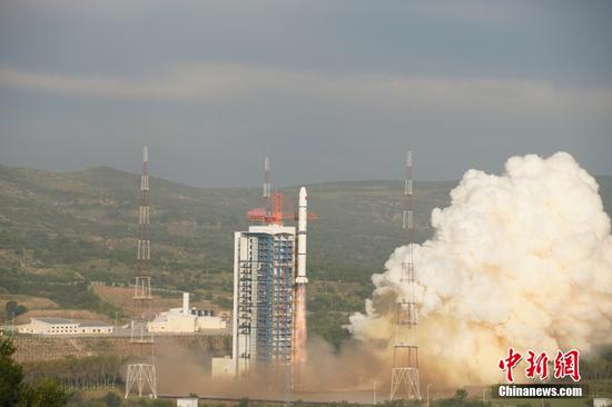
The satellite, named Environmental Surveyor 2F, was carried by a Long March 2C rocket that lifted off at 6:53 am at the Taiyuan Satellite Launch Center in northern China's Shanxi province. It was then placed into a sun-synchronous orbit about 500 kilometers above the ground, the China National Space Administration said in a news release.
Developed by the China Academy of Space Technology in Beijing, the satellite is tasked with using its synthetic aperture radar to obtain images and data to support disaster prevention and mitigation, ecological monitoring, and emergency response efforts. Its users are the Ministry of Emergency Management and the Ministry of Ecology and Environment.
Data generated by the spacecraft will also be used in land and water resources surveys, agricultural yield forecast, and forestry management, the space administration said, noting that the satellite is expected to work in orbit for at least eight years.
China has launched a fleet of satellites to serve the environmental protection and disaster management over the past several years.
The network for which the Environmental Surveyor 2F will work now has four satellites - two equipped with optical cameras and two with synthetic aperture radar. All of them travel in orbits near Earth.
The Long March 2C rocket model is a product of the China Academy of Launch Vehicle Technology. The rocket is mainly used to deploy satellites to low-Earth and sun-synchronous orbits.
The space mission was China's 33rd rocket launch this year and the 482nd flight of the Long March rocket family.


















 京公网安备 11010202009201号