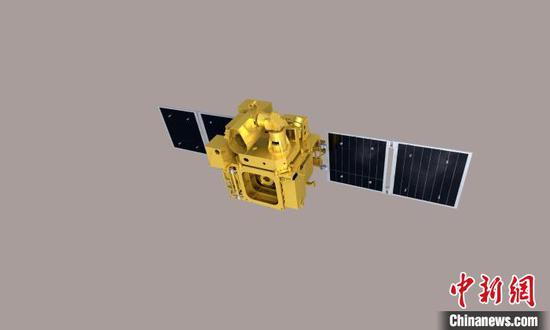
Photo shows the image of satellite Jilin-1 02A03. (Photo provided to China News Service)
(ECNS) -- China's first commercial remote sensing satellite company, Changguang Satellite Technology, introduced the new satellite Jilin-1 02A03, which can carry multiple satellite payloads, in Changchun, northeast China's Jilin Province on Wednesday.
The number of Jilin-1 satellites currently in orbit totals 115, making it the largest sub-meter-level commercial remote sensing constellation in the world. It has become a key global source of aerospace remote sensing data.
The self-developed Jilin-102A03is a low-cost, high-capacity, high-resolution shared remote sensing satellite with independent business capabilities.
By providing payload services, the satellite can share its resources with users, distributing development costs and improving cost-effectiveness .
The main payload of the Jilin-1 02A03 satellite is a lightweight optical remote sensing camera, which can provide users with images bearing a resolution of 0.75 meters and a frame width of over 17 kilometers.
It is also loaded with the "Tianzhi" supercomputing micro-system system, a reflective snapshot compression hyperspectral remote sensing and GRID-11B payload.
Developed by the Institute of Software of Chinese Academy of Sciences, the Tianzhi supercomputer micro-system is mainly used to verify the capabilities of satellite autonomous mission planning, intelligent processing of on-board remote sensing, and accurate calculation of satellite sensors.
The reflective snapshot compression hyperspectral remote sensing payload, developed by Beijing University of Posts is equipped to verify the application value of computational spectral imaging in remote sensing detection. The GRID-11B payload enables 24-hour observation of gamma-ray bursts in orbit.
The satellite weighs at 20 kilograms, and 52 kilograms with payload, reducing costs effectively.
It is scheduled to be launched from the Jiuquan Satellite Launch Center in October, according the company.


 京公网安备 11010202009201号