Ever see your neighbors building an "extension" to their homes illegally? Illegal constructions can be hard for the governments to detect.
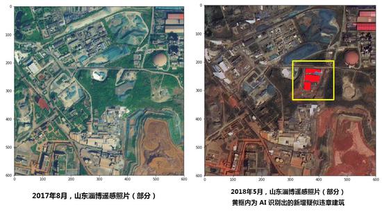
But the local government in eastern China's Zibo may have found a much faster solution: satellite images and AI analysis.
Partnered with Internet giant Alibaba, the civil servants can now use the recently-launched Gaofen-6 satellite to take high-resolution photos of the city and then compare them with old photos using AI.
The machine can find illegal constructions within a minute, while humans have to take as long as three months to get the same result.
The speed benefit matters as the AI allows the government to spot illegal construction in time and stop the builders.
"We used to do the comparison manually. A full scan of the city can take our two experts a season. When we found the structure, it may have already been there for weeks," a civil servant in the Land and Resources Bureau of Zibo city told Global Times.
Zibo is the first city in China to use this method. And now the local government can monitor land use on a monthly basis instead of yearly.
The AI team working for Alibaba said the satellite images can be used to monitor many more things, such as forest and environmental protection and water resources usage.


