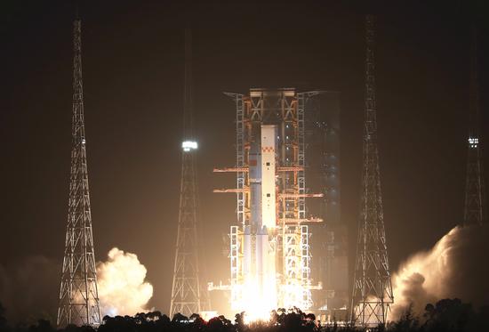
Following a three-year interval after the dense networking of the BeiDou Navigation Satellite System (BDS) global constellation was completed, the first backup satellite was launched on Wednesday morning. The launch will enhance the system's service performance, enabling users to achieve more rapid and precise positioning.
The satellite is of great significance for promoting the distinctive services of the BDS and supporting its large-scale application, by increasing the communication capacity of regional short messaging and improving the performance of satellite-based augmentation and precise point positioning services.
Via a Long March-3B carrier rocket, the 56th BeiDou satellite lifted off from the Xichang Satellite Launch Center. After entering orbit and completing in-orbit testing, it will be integrated into the BDS.
In 2009, the BeiDou-3 project was officially initiated, marking China's efforts to build its own global satellite navigation system. Different from foreign navigation systems, China's BeiDou-3 system adopts a mixed constellation mode, consisting of 30 satellites in three different orbits: 24 medium-Earth orbit satellites, three inclined geosynchronous orbit satellites, and three geostationary Earth orbit (GEO) satellites.
While the number of GEO satellites is relatively small, they play a crucial role in supporting distinctive services and are thus affectionately known as the "Ji Xing", or "lucky stars".
The 56th satellite launched this time inherited the distinctive features of its predecessors, which include basic positioning, navigation, timing, regional short message services, precise point positioning and satellite-based augmentation. It will provide navigation and augmentation services to users in China and surrounding regions.
"Over the past three years, the BDS has been continuously providing high-quality services to users worldwide with steady operation. With the launch of this backup satellite, the service performance of the system will be further enhanced," Yang Changfeng, chief designer of the BDS and research fellow at the Chinese Academy of Engineering, told the Global Times.
Yang noted that this launch is expected to enhance the system's availability and robustness. The backup satellite will also expand the system's capacity of short message communication services in the Belt and Road Initiative (BRI) region by one-third, as well as strengthening the star-based augmentation and precise single-point positioning service capabilities.
Enhancing the product performance of the satellite will drive the sustainable development of the entire navigation system, the chief engineer said.
The date of the launch also coincides with the 65th anniversary of late Chairman Mao Zedong's call to "develop artificial satellites." After more than half a century's dedication, the BDS system has become the largest and most extensive space system ever built in China, with the highest service performance and the closest connection to people's lives. It has entered the fast lane of large-scale application development.
More than 7.9 million road transport vehicles, over 40,000 postal expressway vehicles, more than 47,000 ships and more than 100,000 human-machine autonomous driving systems use the BDS.
Last year, 260 million newly registered domestic smartphones in China, accounting for 98.5 percent of the total, supported the use of BDS. As of January this year, the daily positioning volume of major domestic map applications using BDS had exceeded 300 billion, suggesting that BDS has acquired a dominant position in the domestic navigation map market.
In 2021, the output value of China's navigation and positioning service industry was about 470 billion yuan, and it's estimated to have exceeded 500 billion yuan in 2022.
"Only imagination can limit the application scope of BeiDou," Yang said.
The China-developed navigation system is open to the world, providing high-quality products and first-class services to global users.
It has achieved compatibility and interoperability with the US GPS and Russian GLONASS systems, and continues to engage in interoperability coordination with the Galileo system.
BDS products have been applied in more than half of the countries and regions worldwide, serving hundreds of millions of users. Based on BeiDou, solutions have been applied in land rights confirmation, precision agriculture, disaster prevention and reduction, and smart ports in the ASEAN region, South Asia, Eastern Europe, Africa and elsewhere.
"The BDS system has become a vivid example demonstrating how the BRI benefits the world and promotes the construction of a community with a shared future," Yang said.
The 55th satellite of the BDS, also a GEO satellite and the last one of the BDS-3 system, was launched in June 2020, marking the completion of the deployment of China's own global navigation system.
The BDS' accuracy in worldwide positioning is better than 4.4 meters, which is comparable to that of the US GPS, with the performance of BDS in the Asia-Pacific region even better, according to Chen Gucang, deputy director of the China Satellite Navigation Office in April last year.















 京公网安备 11010202009201号